NWFWMD Specific-use Data Sites
The Northwest Florida Water Management District sponsors the following specific-use data sites to assist the public in making informed decisions. The data provided through the specific-use sites are for informational purposes only. By clicking the links below you will be re-directed to the sponsored site
NWFWMD Flood Information Portal
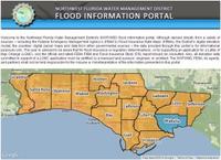
The Northwest Florida Water Management District’s (NWFWMD) flood information portal. Although derived directly from a variety of sources – including the Federal Emergency Management Agency’s (FEMA’s) Flood Insurance Rate Maps (FIRMs), the District’s digital elevation model, the counties’ digital parcel maps and data from other governmental sources – the data provided through this portal is for informational purposes only.
NWFWMD Public LiDAR Data Server
The District’s Public LiDAR Data Server is no longer operational.
To request this information, please contact:
John Crowe, CFM – Hydrologist IV
850-539-5999
john.crowe@yopmail.com
Information about NWFWMD Public LiDAR Data Server.
NWFWMD Map Modernization Program
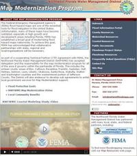
The Northwest Florida Water Management District’s (NWFWMD) Map Modernization Program. The Map Modernization Program is a cooperating Technical Partner (CTP) Agreement with FEMA and NWFWMD to provide local communities with the tools and resources for managing, assessing, and planning for development and construction in flood prone areas to save lives and protect property. Mutually beneficial partnerships will be fostered that will achieve shared outcomes through the communication of flood risk and other hazard information and improve the systems that support them.
NWFWMD Regional Wetlands Mitigation
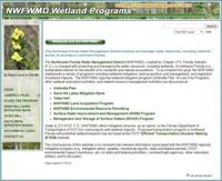
The Northwest Florida Water Management District’s (NWFWMD) Regional Wetland Mitigation Program. NWFWMD is charged with protecting and managing the water resources, including wetlands, of northwest Florida in a sustainable manner for the benefit of its residents and natural ecosystems. The chief purpose of this website is to communicate relevant information associated with the NWFWMD regional mitigation program (e.g., mitigation plans, updates, monitoring reports, state and federal permits, FDOT environmental impact inventories, etc.) to state and federal permitters, commenting agencies, other interested entities, and to the public.