
Hurricane Michael
Hurricane Michael Resources
Damage and Recovery Assessment Map
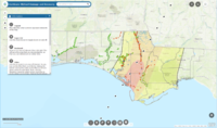
The District created this map to help show the areas impacted by Hurricane Michael. To access the map, simply click on this link: https://nwfwmd.maps.arcgis.com/apps/webappviewer/index.html?id=7666fbd775264133a16deebeeafab87b
Flood Protection Overview
The District promotes flood protection using non-structural techniques, which include acquiring and maintaining floodplains, regulatory activities, and providing technical expertise to local governments and state and federal agencies for flood protection programs.
In December 2002, the District took responsibility for modernizing flood hazard maps into a digital format for the 16 counties of Northwest Florida through a Cooperating Technical Partner agreement with the Federal Emergency Management Agency (FEMA). As a result of this partnership and associated efforts, all of of the panhandle now has digital flood insurance rate maps (DFIRMs).
FEMA has also initiated the Risk Mapping, Assessment, and Planning (Risk MAP) program, which includes collaboration with state and local agencies – including the District – to deliver quality data to increase public awareness of and support for actions that reduce flood-related risks. The general goal of the program is to foster informed risk management decisions and actions that mitigate flood risk through a consistent approach to assessing potential vulnerability and losses.
Flood Protection Resources
NWFWMD Flood Information Portal
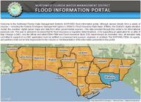
The District’s Flood Information Portal provides residents and business owners in Northwest Florida with an interactive tool to to view flood maps and detailed flood information down to the individual parcel level. The portal compiles flood information directly from a variety of sources, including the Federal Emergency Management Agency’s (FEMA’s) Flood Insurance Rate Maps (FIRMs), the counties’ digital parcel maps, and data from governmental sources.
NWFWMD Public LiDAR Data Server
The District’s Public LiDAR Data Server is no longer operational.
To request this information, please contact:
John Crowe, CFM – Hydrologist IV
850-539-5999
Or you can access this information directly by clicking information about.
NWFWMD Map Modernization Program
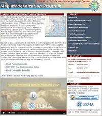
The District is partnering with FEMA and other agencies to provide local communities with the tools and resources for managing, assessing, and planning for development and construction in flood prone areas to save lives and protect property.