
Minimum Flows & Minimum Water Levels
Overview
Water Management Districts in Florida are required to establish Minimum Flows and Minimum Water Levels (MFLs) for selected waterbodies within their boundaries under Section 373.042 (1), Florida Statutes. Minimum Flows and Minimum Water Levels are defined as the limit beyond which further withdrawals would be significantly harmful to the water resources or the ecology of the area. MFLs are not used for offsetting the effects of drought, sea level rise, precipitation patterns, or any other effects unrelated to the impacts of consumptive withdrawals.
Minimum Flows and Minimum Water Levels are established for priority waterbodies within the boundaries of each water management district. These waterbodies are listed on each District’s MFL Priority List and Schedule which is submitted to and approved by the Florida Department of Environmental Protection annually. Waterbodies included on the MFL Priority List include:
- Outstanding Florida Springs, as defined in Section 373.802, Florida Statutes. Minimum flows are required to be established for the District’s Outstanding Florida Springs by July 1, 2026. There are three Outstanding Florida Springs located within the District boundaries: Wakulla Spring, Jackson Blue Spring, and the Gainer Spring Group.
- Second magnitude springs discharging between 10 and 100 cubic feet per second (cfs) of water located on state-owned lands purchased for conservation purposes, unless the District submits a report to the Department of Environmental Protection demonstrating that adverse impacts from consumptive uses are not currently occurring nor reasonably expected to occur within the next 20 years.
- Waterbodies (including springs, lakes, rivers, streams, and aquifers) determined to be at risk for significant harm due to consumptive withdrawals.
Priority List and Schedules
The District is committed to moving forward with MFL development, and has set an ambitious, yet realistic schedule. Each year, Florida’s five water management districts must submit a priority list and schedule for the establishment of MFLs within their region to the Florida Department of Environmental Protection for review and approval.
Northwest Florida Water Management District Minimum Flows and Levels Priority List 2025
| Waterbody Name | Waterbody Type3 | County(s) | Technical Assessment Complete | Anticipated Rule Adoption |
| Jackson Blue Spring | Spring-1 | Jackson | 2025 | 2026 |
| Gainer Spring Group | Spring-1 | Bay | 2024 | 2025 |
| Sylvan Spring Group | Spring-2 | Bay | 2024 | 2025 |
| Williford Spring Group | Spring-2 | Washington | 2024 | 2025 |
| Coastal Floridan Aquifer | Aquifer | Bay | 2027 | 2028 |
| Morrisson Spring | Spring-2 | Walton | 2031 | 2032 |
| Shoal River | River | Okalossa | 2033 | 2034 |
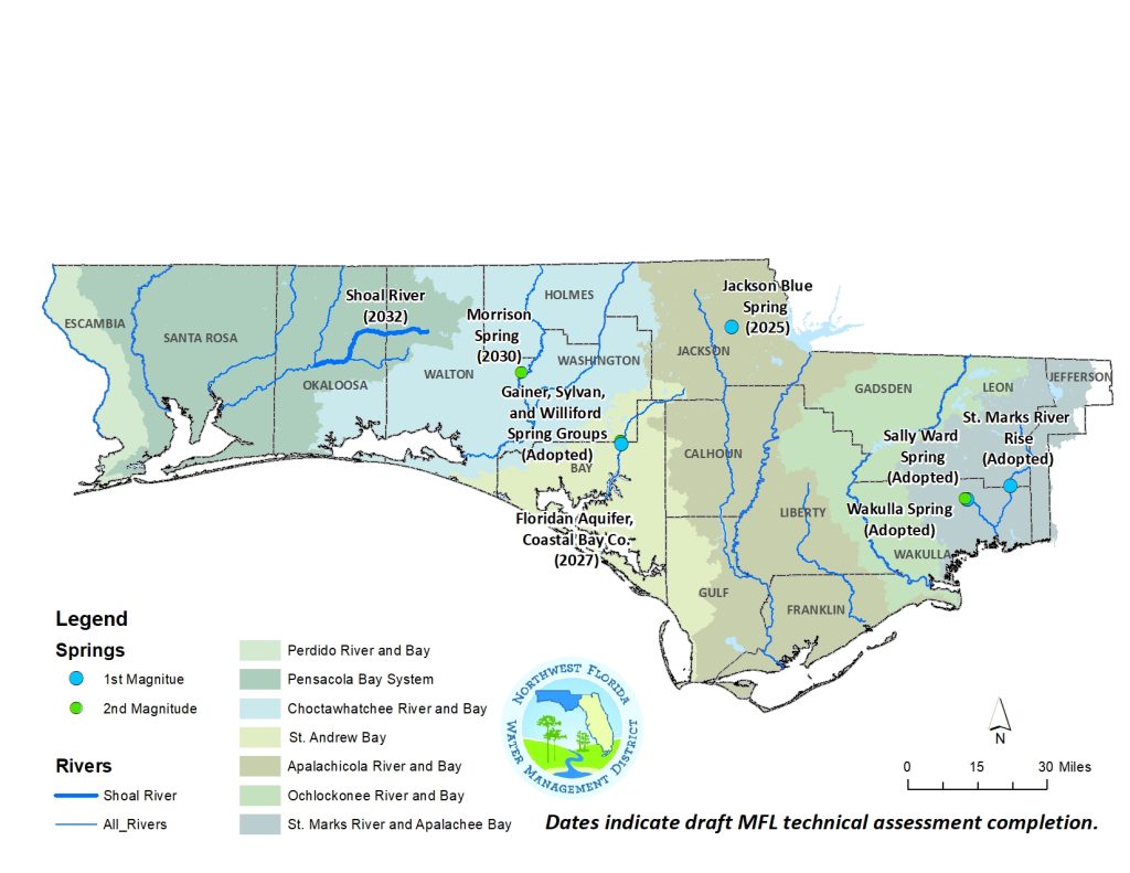
Location of Established and 2025 Northwest Florida Water Management District Minimum Flows and Levels Priority List Water Bodies
Development of MFLs
In the establishment of MFLs, water management districts are required to use the “best available information.” In accordance with Rule 62-40.473, Florida Administrative Code, and Section 373.0421, Florida Statutes, the District must consider natural seasonal fluctuations in water flows or levels, non-consumptive uses, structural alterations, and ten environmental values (referred to as Water Resource Values or WRVs), when developing the minimum flows. These (WRVs) include:
- Recreation in and on the water;
- Fish and wildlife habitats and the passage of fish;
- Estuarine Resources;
- Transfer of detrital material;
- Maintenance of freshwater storage and supply;
- Aesthetic and scenic attributes;
- Filtration and absorption of nutrients and other pollutants;
- Sediment loads;
- Water quality; and,
- Navigation.
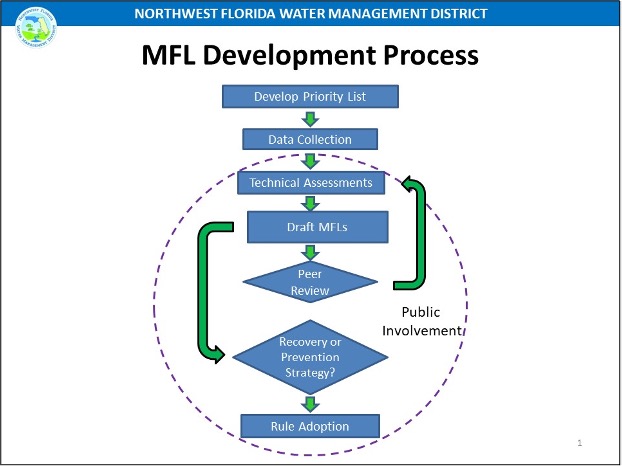
The completion of an MFL Technical Assessment is a complex process which takes multiple years to complete. Once a waterbody is placed on the Priority List, extensive data collection is performed involving the collection of water levels, flows, water quality, physical information describing the system, and ecological data such as the presence of listed species and habitat types. These data are then used to determine appropriate WRV metrics. These metrics are quantifiable measures that relate WRVs to changes in flow or water levels. Hydrologic models capable of simulating changes in water levels and flows under different environmental and withdrawal conditions are developed. These models are then used to determine the flow(s) or level(s) of water required in a waterbody to ensure that significant harm to water resources and ecology is not caused by consumptive uses.
Although significant harm is not specifically defined in statute, an allowable 15 percent reduction in WRV metrics has been implemented as the protection standard for multiple MFLs throughout Florida, recognizing that additional data collection and long-term research to confirm or refine this threshold for MFL assessments in Florida would be beneficial.
Following the completion of the draft Technical Assessment, the work is subjected to a scientific peer review where established experts review the data, assumptions, and analysis completed by the District. Public involvement is integral and generally occurs throughout the duration of an MFL project, including opportunities to review the data and the technical assessment. Once finalized, the MFL Technical Assessment is then used to help establish the MFL criteria for the waterbody. The criteria are used to develop formal rule language, which must then be adopted and included in Florida Administrative Code Chapter 40A-8.
At the time of rule adoption, water management districts are required to develop and implement a recovery strategy when a system is currently not meeting MFL criteria or a prevention strategy if the MFL is expected to not be met during the following 20 years based on projected withdrawals. Prevention/recovery strategies may include water conservation measures and additional water supply or water resource development projects. Currently, no prevention or recovery strategies are required for any NWFWMD waterbodies with established minimum flows.
MFL implementation follows an adaptive management approach, with MFLs periodically reviewed and reevaluated by the District to reflect new data and information. As new data and information become available regarding the definition of or threshold for significant harm, the District will consider this information in future MFL re-evaluations.
MFL Documents
Middle Econfina Creek, including Gainer, Sylvan, and Williford spring groups
Middle Ecofina Creek MFL – Final Technical Assessment
Middle Econfina Creek MFL – Appendix A HEC-RAS Technical Report
Middle Econfina Creek MFl – Appendix B SEFA Technical Report
Middle Econfina MFL – Peer Review
Middle Econfina MFL – District Responses to Peer Review
Coastal Floridan Aquifer in Planning Region II (Santa Rosa, Okaloosa, and Walton counties)
R2 MFL Technical Evaluation final report
Region 2 MFL Technical Evaluation – Appendix A RegII Geophysical Investigation Report
Region 2 MFL Technical Evaluation – Appendix B RegII Well Construction and Testing A-4
Region 2 MFL Technical Evaluation – Appendix C RegII Well Construction and Testing A-3e
Region 2 MFL Technical Evaluation – Appendix D RegII Well Construction and Testing A-2
Region 2 MFL Technical Evaluation – Appendix E RegII Well Construction and Testing B-2
Region 2 MFL Technical Evaluation – Appendix F RegII Discrete WQ Sampling Fall2017
Region 2 MFL Technical Evaluation – Appendix G RegII Discrete WQ Sampling Summer2018
Region 2 MFL Technical Evaluation – Appendix H RegII Discrete WQ Sampling Winter2019
Region 2 MFL Technical Evaluation – Appendix I Plots of Sig Inc WQ Trends
Region 2 MFL Technical Evaluation – Appendix J Plots of Sig Dec WQ Trends
Region 2 MFL Technical Evaluation – Appendix K Construction of Coastal RegII SEAWAT model
Region 2 MFL Technical Evaluation – Appendix L Transient Calibration R2MF Model 1report
Region 2 MFL Technical Evaluation – Appendix_L_Transient_Calibration_R2MF_Model_2Figs_Tables
Region 2 MFL Technical Evaluation – Appendix L Transient Calibration R2MF Model 3Append
Region 2 MFL Technical Evaluation – Appendix M Calibration Transient CR2SWT Model 1report
Region 2 MFL Technical Evaluation – Appendix M Calibration Transient CR2SWT Model 2Figs Tables
Region 2 MFL Technical Evaluation – Appendix N CR2SWT Model Predictive Sims 1report
Region 2 MFL Technical Evaluation – Appendix N CR2SWT Model Predictive Sims 2Figs
Region 2 MFL Technical Evaluation – Appendix N CR2SWT Model Predictive Sims 3Tables
Wakulla and Sally Ward Spring System
Wakulla and Sally Ward Springs – 40A-8 Coded Rule Text (DRAFT)
Wakulla and Sally Ward Springs – Technical Assessment Report
Wakulla and Sally Ward Springs – Technical Assessment Report – Appendix A – Baseline Time Series
Wakulla and Sally Ward Springs – Technical Assessment Report – Appendix B – Estuarine
Wakulla and Sally Ward Springs – Technical Assessment Report – Appendix B-1 – Estuarine
Wakulla and Sally Ward Springs – Technical Assessment Report – Appendix C – Thermal Refuge
Wakulla and Sally Ward Springs – Technical Assessment Report – Appendix C-1 – Thermal Refuge
Wakulla and Sally Ward Springs – Technical Assessment Report – Appendix D – HECRAS
Wakulla and Sally Ward Springs – Technical Assessment Report – Appendix E – Estuarine St. Marks River Rise
Wakulla and Sally Ward Springs – Peer Review (Final report)
St. Marks River Rise
St. Marks River Rise – FINAL Technical Assessment Report
St. Marks River Rise – Peer Review Report
St. Marks River Rise – Public Workshop Presentation
St. Marks River Rise – Technical Assessment Report – Appendix A HECRAS
St. Marks River Rise – Technical Assessment Report – Appendix B Baseline Time Series
St. Marks River Rise – Technical Assessment Report – Appendix C-2 Ecology Analysis
St. Marks River Rise – Technical Assessment Report – Appendix C-2 Ecology Data Collection TM2015
St. Marks River Rise – Technical Assessment Report – Appendix D EFDC
St. Marks River Rise – Technical Assessment Report – Appendix E Consideration of PHABSIM